You are here
Real Time Data Graphs
These graphs display selected data from our weather station & stream gages. Each graph shows measurements over the last 30 days and is updated every 15 minutes.
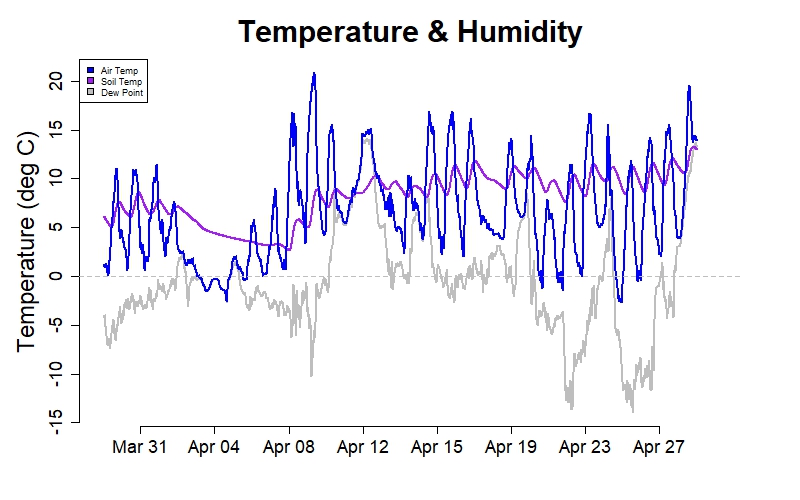
Air temperature, soil temperature (10-cm depth), and dew point in degrees Celsius (15-minute averages). Air temperature shows hourly, daily, and seasonal patterns related to changes in cloud cover, synoptic weather, sun angle, and length of day. Soil temperature shows similar patterns but changes more slowly and often hovers near freezing in winter. Dew point is a good predictor of minimum temperature on calm, clear nights. (See all real-time data graphs.)
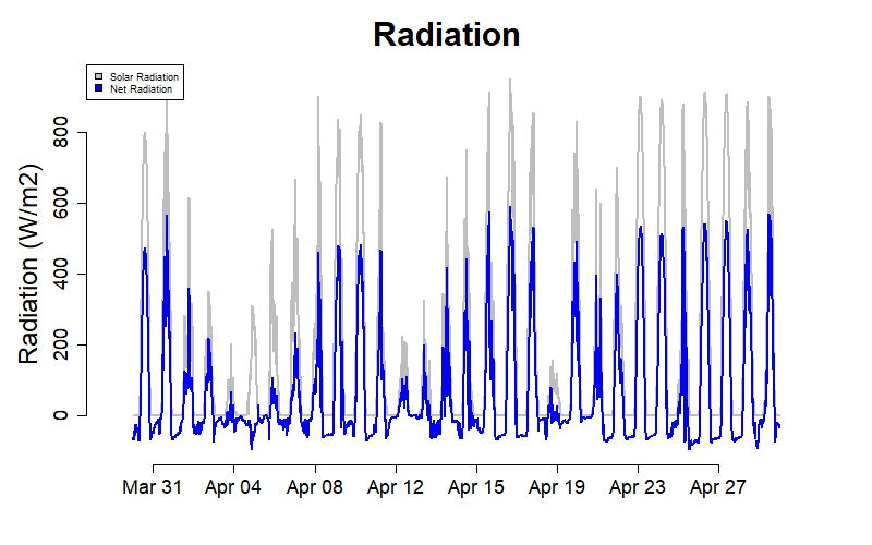
Solar and net radiation in watts per square meter (15-minute averages). Solar radiation is affected by sun angle, cloud cover, and relative humidity; while net radiation is also affected by ground temperature and snow cover. Seasonal trends in solar radiation may be observed by comparing peak values on clear days. Net radiation decreases with snow cover and increases with cloud cover. (See all real-time data graphs.)
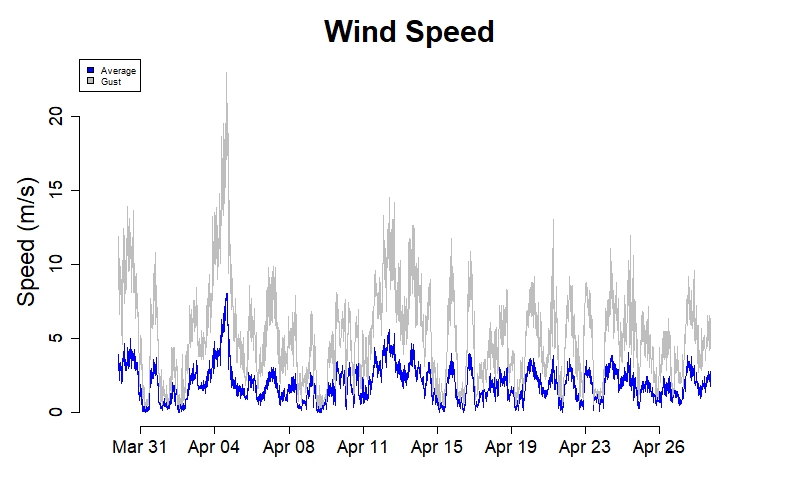
Average wind speed and peak gust speed in meters per second (15-minute values) measured at 10 meters above the ground. Wind speed is highly variable but tends to be greater during the day, during certain weather events (e.g., storms, frontal passages), and during the winter months. At this station, peak 1-second wind gust speeds (in each 15-minute period) are typically about 2.8 times the average wind speed. (See all real-time data graphs.)
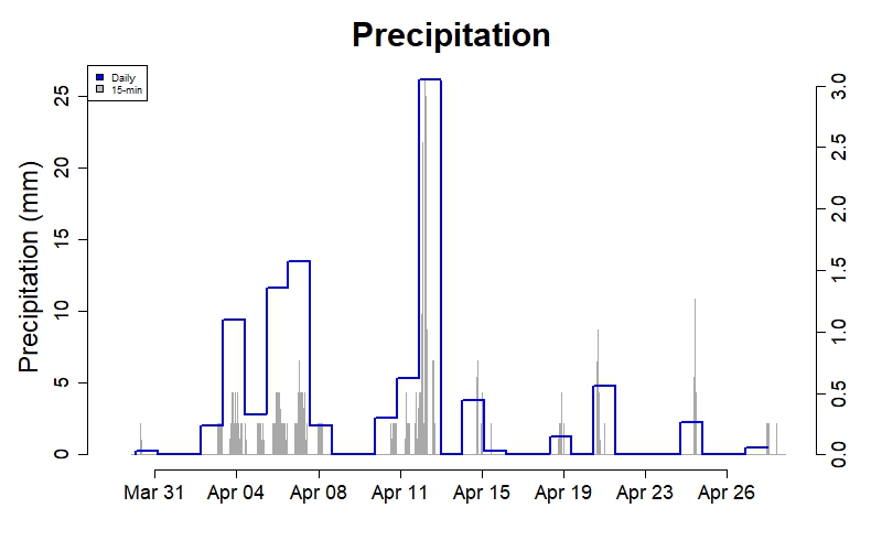
Precipitation in millimeters (daily and 15-minute totals) including melted snow and ice. On average, precipitation is distributed evenly throughout the year. However there is considerable variation from day to day and from month to month. Droughts are rare but do occur. Major floods are often associated with heavy rain on snowpack (late winter - early spring) or tropical storms (late summer - early fall). (See all real-time data graphs.)
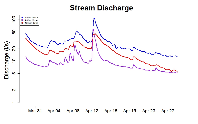
Stream discharge in liters per second (15-minute averages on a log scale) from three small forested watersheds. Discharge shows hourly, daily, and seasonal patterns related to precipitation, snow melt, soil moisture, ground water, and evapo-transpiration. Differences among watersheds are related to watershed size, geomorphology, vegetation cover, and presence or absence of wetlands. (See all real-time data graphs.)
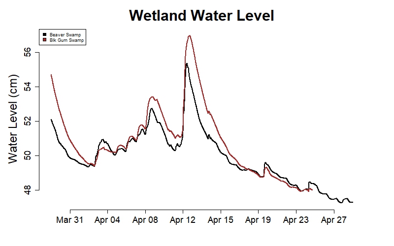
Water level in centimeters (15-minute averages). The Black Gum Swamp and smaller Beaver Swamp act to buffer flow in the Nelson and lower Bigelow watersheds. The Black Gum Swamp is the source of Nelson Brook and has no significant stream inputs; while Bigelow Brook flows through the Beaver Swamp. Water levels in these wetlands (especially the BGS) provide an indication of below-ground water storage during dry periods. (See all real-time data graphs.)
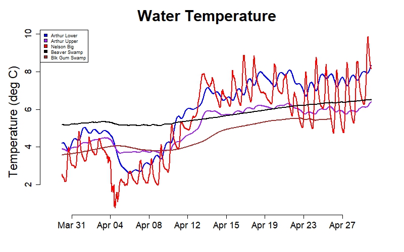
Water temperature in degrees Celsius (15-minute averages). Stream water temperatures show hourly, daily, and seasonal patterns. Upper Bigelow Brook tends to be warmer in winter and cooler in summer because some of its flow is below ground. Wetland water temperatures show similar patterns but change more slowly, with warmer winter temperatures and cooler summer temperatures than their outlet streams. (See all real-time data graphs.)
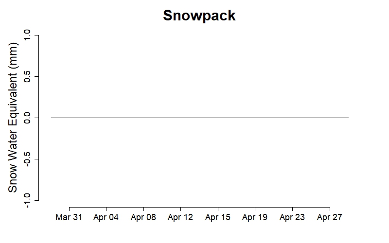
Snow water equivalent in millimeters (15-minute averages) measured at the Harvard Forest Snow Pillow. In central New England, much of the water that falls as snow and ice in winter months is stored in the snowpack and released in the spring. The snow pillow is located in a mature mixed hardwood stand with scattered conifers. (See all real-time data graphs.)

